
Sende topographic map
Interactive map
Click on the map to display elevation.
About this map
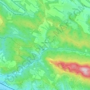
Name: Sende topographic map, elevation, terrain.
Average elevation: 850 ft
Minimum elevation: 338 ft
Maximum elevation: 2,123 ft
Other topographic maps
Click on a map to view its topography, its elevation and its terrain.
Galgaguta
Galgaguta, Balassagyarmati járás, Komitat Neuburg, Nordungarn, Nördliche Große Tiefebene, 2686, Ungarn
Average elevation: 702 ft
Neuburg
Ungarn > Komitat Neuburg > Neuburg
Neuburg, Rétsági járás, Komitat Neuburg, Nordungarn, Nördliche Große Tiefebene, 2642, Ungarn
Average elevation: 866 ft