
Cieneguitas topographic map
Interactive map
Click on the map to display elevation.
About this map
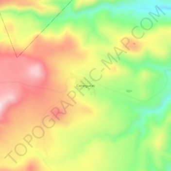
Name: Cieneguitas topographic map, elevation, terrain.
Location: Cieneguitas, Canatlán, Durango, México (24.55860 -105.00762 24.59860 -104.96762)
Average elevation: 8,136 ft
Minimum elevation: 7,448 ft
Maximum elevation: 8,796 ft
Other topographic maps
Click on a map to view its topography, its elevation and its terrain.
Donato Guerra
Donato Guerra, Canatlán, Durango, México
Average elevation: 6,545 ft
Colonia Anáhuac
Colonia Anáhuac, Canatlán, Durango, México
Average elevation: 6,388 ft