
Aigio topographic map
Interactive map
Click on the map to display elevation.
About this map
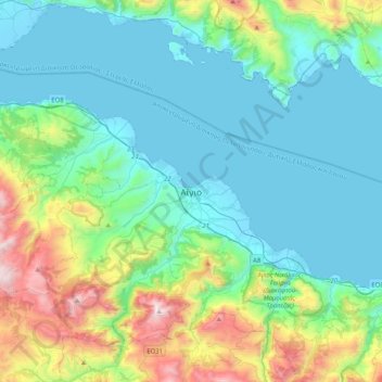
Name: Aigio topographic map, elevation, terrain.
Average elevation: 1,217 ft
Minimum elevation: -13 ft
Maximum elevation: 5,705 ft
Other topographic maps
Click on a map to view its topography, its elevation and its terrain.
Patras
Greece > Peloponnese, Western Greece and the Ionian > Achaia Regional Unit
Patras, Municipal Unit of Patras, Municipality of Patras, Achaia Regional Unit, Western Greece, Peloponnese, Western Greece and the Ionian, 262 21, Greece
Average elevation: 928 ft
Municipality of Patras
Greece > Peloponnese, Western Greece and the Ionian > Achaia Regional Unit
Municipality of Patras, Achaia Regional Unit, Western Greece, Peloponnese, Western Greece and the Ionian, Greece
Average elevation: 955 ft