
Puerto Real topographic map
Interactive map
Click on the map to display elevation.
About this map
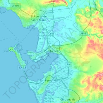
Name: Puerto Real topographic map, elevation, terrain.
Location: Puerto Real, Bay of Cádiz, Cádiz, Andalusia, Spain (36.45579 -6.25911 36.59939 -5.98013)
Average elevation: 59 ft
Minimum elevation: -23 ft
Maximum elevation: 404 ft
Other topographic maps
Click on a map to view its topography, its elevation and its terrain.
Cádiz
Spain > Andalusia > Bay of Cádiz
Cádiz, Bay of Cádiz, Cádiz, Andalusia, Spain
Average elevation: 3 ft
Chiclana de la Frontera
Spain > Andalusia > Bay of Cádiz
Chiclana de la Frontera, Bay of Cádiz, Cádiz, Andalusia, Spain
Average elevation: 79 ft
El Puerto de Santa María
Spain > Andalusia > Bay of Cádiz
El Puerto de Santa María, Bay of Cádiz, Cádiz, Andalusia, Spain
Average elevation: 69 ft
San Fernando
Spain > Andalusia > Bay of Cádiz
San Fernando, Bay of Cádiz, Cádiz, Andalusia, Spain
Average elevation: 20 ft