
Hirzbrunnen topographic map
Interactive map
Click on the map to display elevation.
About this map
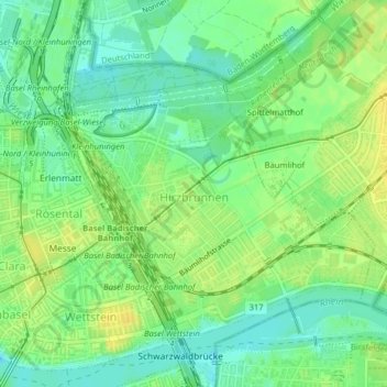
Name: Hirzbrunnen topographic map, elevation, terrain.
Location: Hirzbrunnen, Basel, Basel-Stadt, 5068, Schweiz (47.55876 7.60066 47.57942 7.63414)
Average elevation: 853 ft
Minimum elevation: 817 ft
Maximum elevation: 889 ft
Other topographic maps
Click on a map to view its topography, its elevation and its terrain.
Kleinbasel
Schweiz > Basel-Stadt > Basel
Kleinbasel, Basel, Basel-Stadt, 4058, Schweiz
Average elevation: 856 ft
St. Johann
Schweiz > Basel-Stadt > Basel
St. Johann, Basel, Basel-Stadt, Schweiz
Average elevation: 869 ft
Bruderholz
Schweiz > Basel-Stadt > Basel
Bruderholz, Basel, Basel-Stadt, 4059, Schweiz
Average elevation: 1,047 ft
Altstadt Kleinbasel
Schweiz > Basel-Stadt > Basel
Altstadt Kleinbasel, Basel, Basel-Stadt, Schweiz
Average elevation: 876 ft