
Make a donation
Gear up for your next adventure:
As an Amazon Associate, this site earns from qualifying purchases at no extra cost to you.
Berastegi topographic map
Click on the map to display elevation.
Make a donation
Gear up for your next adventure:
As an Amazon Associate, this site earns from qualifying purchases at no extra cost to you.
Berastegi
Berastegi (Spanish: Berástegui) is a town located in the province of Gipuzkoa, in the autonomous community of Basque Country, northern Spain, at the shores of the river Elduaran or Berastegi, at 1° 58' 45" west and 43° 07' 27" north, and at an altitude of 400 m. It borders Ibarra to the north, with Eldua to the east, and to the south and west with Belauntza.
Make a donation
Gear up for your next adventure:
As an Amazon Associate, this site earns from qualifying purchases at no extra cost to you.
About this map
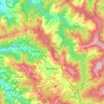
Name: Berastegi topographic map, elevation, terrain.
Average elevation: 1,647 ft
Minimum elevation: 279 ft
Maximum elevation: 3,258 ft
Make a donation
Gear up for your next adventure:
As an Amazon Associate, this site earns from qualifying purchases at no extra cost to you.
Other topographic maps
Click on a map to view its topography, its elevation and its terrain.
Soil
Spain > Autonomous Community of the Basque Country > Montaña Alavesa/Arabako Mendialdea
Average elevation: 2,946 ft