Geolocate

Pinch topographic map

Click on the map to display elevation.

About this map

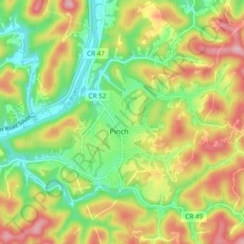
Name: Pinch topographic map, elevation, terrain.

Location: Pinch, Kanawha County, West Virginia, 25156, United States (38.39284 -81.51208 38.42824 -81.44952)

Average elevation: 837 ft

Minimum elevation: 564 ft

Maximum elevation: 1,178 ft

Gear up for your next adventure:

🪶Wildlife Field Guides - Learn animal tracking and species ID
📱Heavy-Duty Phone Cases - Drop-proof and waterproof protection for outdoor navigation
🥾Hiking Shoes - Durable and comfortable shoes for trail hiking
🧼Biodegradable Camping Soap - Eco‑friendly soap for outdoor hygiene
🗃️Trail First Aid Kit - Essential kit for outdoor injuries and emergencies

As an Amazon Associate, this site earns from qualifying purchases at no extra cost to you.