
Río Seco Bajo topographic map
Interactive map
Click on the map to display elevation.
About this map
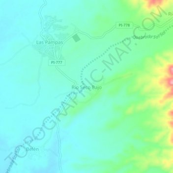
Name: Río Seco Bajo topographic map, elevation, terrain.
Location: Río Seco Bajo, Chulucanas, Morropón, Piura, Perú (-5.03574 -80.16893 -4.99574 -80.12893)
Average elevation: 384 ft
Minimum elevation: 292 ft
Maximum elevation: 705 ft
Other topographic maps
Click on a map to view its topography, its elevation and its terrain.
Km. 50
Perú > Piura > Chulucanas > Km. 50
Km. 50, Chulucanas, Morropón, Piura, Perú
Average elevation: 390 ft
Plaza de Armas
Perú > Piura > Chulucanas
Plaza de Armas, Chulucanas, Morropón, Piura, Perú
Average elevation: 308 ft