
Make a donation
Gear up for your next adventure:
As an Amazon Associate, this site earns from qualifying purchases at no extra cost to you.
Ischigualasto Provincial Park topographic map
Click on the map to display elevation.
Make a donation
Gear up for your next adventure:
As an Amazon Associate, this site earns from qualifying purchases at no extra cost to you.
Ischigualasto Provincial Park
Most of the park lies within the Valle Fértil Department, with a minor part in the Jachal Department of San Juan, at an altitude of about 1,300 m (4,300 ft) amsl. The park is part of the western border of the Central Sierras, and it features typical desert vegetation (bushes, cacti and some trees) which covers between 10 and 20% of the area. The climate is very dry, with rainfall mostly during the summer, and temperature extremes (minimum −10 °C or 14 °F, maximum 45 °C or 113 °F). There is a constant southern wind with a speed of 20–40 km/h (12–25 mph) after noon and until the evening, sometimes accompanied by the extremely strong Zonda wind.
Make a donation
Gear up for your next adventure:
As an Amazon Associate, this site earns from qualifying purchases at no extra cost to you.
About this map
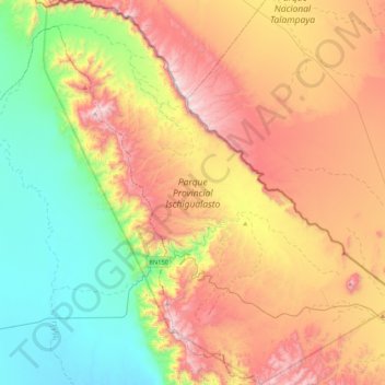
Name: Ischigualasto Provincial Park topographic map, elevation, terrain.
Average elevation: 4,127 ft
Minimum elevation: 2,487 ft
Maximum elevation: 6,329 ft
Make a donation
Gear up for your next adventure:
As an Amazon Associate, this site earns from qualifying purchases at no extra cost to you.
Other topographic maps
Click on a map to view its topography, its elevation and its terrain.
San Juan
San Juan is ranked second among the wine-producing provinces of Argentina. It has a cultivated area of 116,700 acres at altitudes of between 1,970 (601m) and 4,590 feet (1399m) above sea level. This region specializes in Syrah, Malbec, Cabernet Sauvignon, Bonarda, Chardonnay and Torrontés. Because of this…
Average elevation: 2,277 ft
Make a donation
Gear up for your next adventure:
As an Amazon Associate, this site earns from qualifying purchases at no extra cost to you.
Make a donation
Gear up for your next adventure:
As an Amazon Associate, this site earns from qualifying purchases at no extra cost to you.
Make a donation
Gear up for your next adventure:
As an Amazon Associate, this site earns from qualifying purchases at no extra cost to you.