
Asmat topographic map
Interactive map
Click on the map to display elevation.
About this map
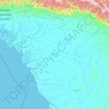
Name: Asmat topographic map, elevation, terrain.
Location: Asmat, Papua, 99777, Indonesien (-6.56543 137.55174 -4.59833 139.64413)
Average elevation: 128 ft
Minimum elevation: -16 ft
Maximum elevation: 9,419 ft
Other topographic maps
Click on a map to view its topography, its elevation and its terrain.
Mamberamo
Mamberamo, Mamberamo Raya, Papua, 99376, Indonesien
Average elevation: 568 ft
Carstensz-Pyramide
Carstensz-Pyramide, Mimika, Papua, Indonesien
Average elevation: 13,993 ft
Biak Kota
Indonesien > Papua > Biak Kota
Biak Kota, Biak Numfor, Papua, 98111, Indonesien
Average elevation: 69 ft
Muba
Indonesien > Papua > Muba
Muba, Distrik Silimo, Yahukimo, Papua, Indonesien
Average elevation: 5,371 ft