
Town of Birdsall topographic map
Interactive map
Click on the map to display elevation.
About this map
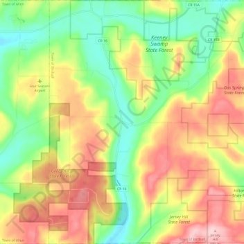
Name: Town of Birdsall topographic map, elevation, terrain.
Location: Town of Birdsall, Allegany County, New York, United States (42.34757 -77.95622 42.43536 -77.83882)
Average elevation: 1,906 ft
Minimum elevation: 1,604 ft
Maximum elevation: 2,254 ft
Other topographic maps
Click on a map to view its topography, its elevation and its terrain.
Town of Grove
United States > New York > Allegany County
Town of Grove, Allegany County, New York, 14884, United States
Average elevation: 1,847 ft
Village of Alfred
United States > New York > Allegany County
Village of Alfred, Town of Alfred, Allegany County, New York, 14802, United States
Average elevation: 1,959 ft
Town of Wellsville
United States > New York > Allegany County
Town of Wellsville, Allegany County, New York, 14895, United States
Average elevation: 1,850 ft
Village of Andover
United States > New York > Allegany County
Village of Andover, Town of Andover, Allegany County, New York, 14806, United States
Average elevation: 1,841 ft
Town of Rushford
United States > New York > Allegany County
Town of Rushford, Allegany County, New York, United States
Average elevation: 1,732 ft
Swain
United States > New York > Allegany County
Swain, Town of Grove, Allegany County, New York, 14884, United States
Average elevation: 1,650 ft
Almond
United States > New York > Allegany County > Almond
Almond, Allegany County, New York, United States
Average elevation: 1,542 ft
Birdsall
United States > New York > Allegany County
Birdsall, Town of Birdsall, Allegany County, New York, United States
Average elevation: 1,909 ft