
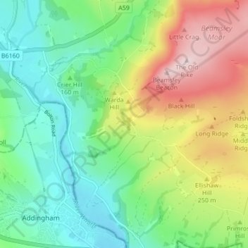
Langbar topographic map
Interactive map
Click on the map to display elevation.
About this map
Name: Langbar topographic map, elevation, terrain.
Average elevation: 636 ft
Minimum elevation: 269 ft
Maximum elevation: 1,296 ft
Other topographic maps
Click on a map to view its topography, its elevation and its terrain.
Great Ayton
Vereinigtes Königreich > England > North Yorkshire
Great Ayton, North Yorkshire, England, Vereinigtes Königreich
Average elevation: 390 ft
Hawes
Vereinigtes Königreich > England > North Yorkshire
Hawes, North Yorkshire, England, Vereinigtes Königreich
Average elevation: 1,411 ft
Normanby
Vereinigtes Königreich > England > North Yorkshire
Normanby, North Yorkshire, England, YO62 6RH, Vereinigtes Königreich
Average elevation: 102 ft
Settle
Vereinigtes Königreich > England > North Yorkshire
Settle, North Yorkshire, England, Vereinigtes Königreich
Average elevation: 781 ft
Hasty Bank
Vereinigtes Königreich > England > North Yorkshire > Ingleby Greenhow
Hasty Bank, Bilsdale Midcable, Ingleby Greenhow, North Yorkshire, England, Vereinigtes Königreich
Average elevation: 787 ft
Carlton in Cleveland
Vereinigtes Königreich > England > North Yorkshire
Carlton in Cleveland, North Yorkshire, England, TS9 7DJ, Vereinigtes Königreich
Average elevation: 394 ft
Muker
Vereinigtes Königreich > England > North Yorkshire > Richmondshire
Muker, Richmondshire, North Yorkshire, England, Vereinigtes Königreich
Average elevation: 1,572 ft
Dalton-on-Tees
Vereinigtes Königreich > England > North Yorkshire > Richmondshire > Dalton-on-Tees
Dalton-on-Tees, Richmondshire, North Yorkshire, Yorkshire and the Humber, England, DL2 2PA, Vereinigtes Königreich
Average elevation: 151 ft
Whitby
Vereinigtes Königreich > England > North Yorkshire
Whitby, Scarborough, North Yorkshire, England, Vereinigtes Königreich
Average elevation: 121 ft
Selby
Vereinigtes Königreich > England > North Yorkshire > Selby
Selby, North Yorkshire, Yorkshire and the Humber, England, Vereinigtes Königreich
Average elevation: 23 ft