
Potosi Mountain topographic map
Interactive map
Click on the map to display elevation.
About this map
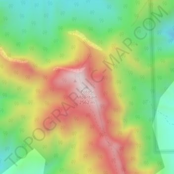
Name: Potosi Mountain topographic map, elevation, terrain.
Location: Potosi Mountain, Clark County, Nevada, USA (35.96576 -115.50117 35.96586 -115.50107)
Average elevation: 7,188 ft
Minimum elevation: 6,132 ft
Maximum elevation: 8,494 ft
Other topographic maps
Click on a map to view its topography, its elevation and its terrain.
Ruby Mountains
Ruby Mountains, National Forest Development Road 343 Trail, Elko County, Nevada, USA
Average elevation: 6,437 ft
River Mountains Loop Trail
USA > Nevada > Boulder City
River Mountains Loop Trail, Boulder City, Clark County, Nevada, 89005, USA
Average elevation: 2,480 ft
Jeff Davis Peak
Jeff Davis Peak, White Pine County, Nevada, USA
Average elevation: 11,260 ft
North Jackson Mountains Wilderness Area
North Jackson Mountains Wilderness Area, Jackson Creek Ranch Road, Humboldt County, Nevada, USA
Average elevation: 5,732 ft
Snake Range
Snake Range, Great Basin National Park, White Pine County, Nevada, USA
Average elevation: 6,509 ft
Wheeler Peak Glacier
Wheeler Peak Glacier, Bristlecone and Glacier Trail, White Pine County, Nevada, USA
Average elevation: 11,483 ft
Whistler Mountain
Whistler Mountain, Eureka County, Nevada, USA
Average elevation: 7,254 ft