
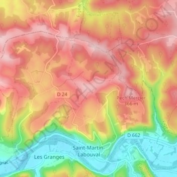
Saint-Martin-Labouval topographic map
Interactive map
Click on the map to display elevation.
About this map
Name: Saint-Martin-Labouval topographic map, elevation, terrain.
Average elevation: 892 ft
Minimum elevation: 433 ft
Maximum elevation: 1,247 ft
Other topographic maps
Click on a map to view its topography, its elevation and its terrain.
Limogne-en-Quercy
Limogne-en-Quercy, Cahors, Lot, Occitanie, France métropolitaine, 46260, France
Average elevation: 1,004 ft
Le Cingle-Haut
France > Occitanie > Lot > Figeac
Le Cingle-Haut, Figeac, Lot, Occitanie, France métropolitaine, 46100, France
Average elevation: 886 ft
Castelfranc
Castelfranc, Cahors, Lot, Occitanie, France métropolitaine, 46140, France
Average elevation: 525 ft