
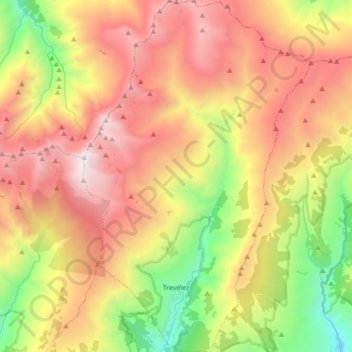
Trevélez topographic map
Interactive map
Click on the map to display elevation.
About this map
Name: Trevélez topographic map, elevation, terrain.
Average elevation: 7,713 ft
Minimum elevation: 3,957 ft
Maximum elevation: 11,394 ft
Located at a height of 1486 metres, Trevélez is not the highest recognised municipality in Spain. That honour goes to Valdelinares located in the Sierra de Gúdar range of the Sistema Ibérico, in the province of Teruel, Aragon, Spain. It lies at the confluence of the Río Trevélez with a smaller stream, to the southwest of Mulhacén, the highest peak of the Sierra Nevada and of the Iberian peninsula. The village lies to the west of the Río Trevélez. It is divided into three parts, the Barrios Bajo, Medio and Alto (lower, mid and upper quarters), with 200 metres of altitude difference between the highest and lowest points. The only bridge over the river is in the Barrio Bajo. The Barrio Bajo is a significant tourist centre, while the Barrios Medio and Alto are more typically Alpujarran in style, though tourism is important to the economy of the entire village. To the west, the nearest village is Busquístar; the road through the Bajo Barrio continues to the east and south to Juviles and Torvizcón. There is a regular bus service along this road, linking the village to the regional centres of Lanjarón and Órgiva as well as the provincial capital, Granada.
Other topographic maps
Click on a map to view its topography, its elevation and its terrain.
Sierra Nevada
Spain > Andalusia > Comarca de la Alpujarra Granadina > Lanjarón
Sierra Nevada, Lanjarón, Comarca de la Alpujarra Granadina, Granada, Andalusia, Spain
Average elevation: 7,293 ft
Pico de Mulhacén
Spain > Andalusia > Comarca de la Alpujarra Granadina > Trevélez
Pico de Mulhacén, Trevélez, Comarca de la Alpujarra Granadina, Granada, Andalusia, Spain
Average elevation: 10,072 ft
Sierra Nevada
Spain > Andalusia > Comarca de la Alpujarra Granadina
Sierra Nevada, Comarca de la Alpujarra Granadina, Granada, Andalusia, Spain
Average elevation: 4,334 ft
Soportújar
Spain > Andalusia > Comarca de la Alpujarra Granadina
Soportújar, Comarca de la Alpujarra Granadina, Granada, Andalusia, 18410, Spain
Average elevation: 6,125 ft
Pico del Veleta
Spain > Andalusia > Comarca de la Alpujarra Granadina > Capileira
Pico del Veleta, Capileira, Comarca de la Alpujarra Granadina, Granada, Andalusia, 18196, Spain
Average elevation: 9,836 ft
Capileira
Spain > Andalusia > Comarca de la Alpujarra Granadina
Capileira, Comarca de la Alpujarra Granadina, Granada, Andalusia, 18413, Spain
Average elevation: 7,822 ft
Cáñar
Spain > Andalusia > Comarca de la Alpujarra Granadina > Cáñar
Cáñar, Comarca de la Alpujarra Granadina, Granada, Andalusia, Spain
Average elevation: 5,958 ft
Río Guadalfeo
Spain > Andalusia > Comarca de la Alpujarra Granadina
Río Guadalfeo, Comarca de la Alpujarra Granadina, Granada, Andalusia, 18440, Spain
Average elevation: 2,799 ft
Bubión
Spain > Andalusia > Comarca de la Alpujarra Granadina
Bubión, Comarca de la Alpujarra Granadina, Granada, Andalusia, 18412, Spain
Average elevation: 6,985 ft
Mecina Bombarón
Spain > Andalusia > Comarca de la Alpujarra Granadina > Alpujarra de la Sierra
Mecina Bombarón, Alpujarra de la Sierra, Comarca de la Alpujarra Granadina, Granada, Andalusia, 18450, Spain
Average elevation: 4,239 ft
Mecina Alfahar
Spain > Andalusia > Comarca de la Alpujarra Granadina > Válor
Mecina Alfahar, Válor, Comarca de la Alpujarra Granadina, Granada, Andalusia, 18470, Spain
Average elevation: 3,104 ft