
Bezirk Neutitschein topographic map
Interactive map
Click on the map to display elevation.
About this map
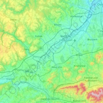
Name: Bezirk Neutitschein topographic map, elevation, terrain.
Average elevation: 1,220 ft
Minimum elevation: 673 ft
Maximum elevation: 3,681 ft
Other topographic maps
Click on a map to view its topography, its elevation and its terrain.
Braunsdorf
Tschechien > Mährisch-Schlesien > Mährisch-Schlesische Region
Braunsdorf, Bezirk Troppau, Mährisch-Schlesische Region, Mährisch-Schlesien, 747 71, Tschechien
Average elevation: 1,096 ft