
Cerro Chorrillo topographic map
Interactive map
Click on the map to display elevation.
About this map
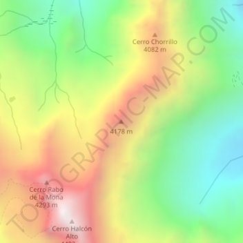
Name: Cerro Chorrillo topographic map, elevation, terrain.
Average elevation: 12,293 ft
Minimum elevation: 10,315 ft
Maximum elevation: 14,724 ft
Other topographic maps
Click on a map to view its topography, its elevation and its terrain.
Nevado Olivares
Chile > Región de Valparaíso > Los Andes
Nevado Olivares, Los Andes, Provincia de Los Andes, Región de Valparaíso, Chile
Average elevation: 14,944 ft