
Make a donation
Gear up for your next adventure:
As an Amazon Associate, this site earns from qualifying purchases at no extra cost to you.
Mar Chiquita topographic map
Click on the map to display elevation.
Make a donation
Gear up for your next adventure:
As an Amazon Associate, this site earns from qualifying purchases at no extra cost to you.
Mar Chiquita
There are several islands in the lake, the most important one being the Médano Island. Mar Chiquita is slowly diminishing in volume due to increased evaporation and elevation of its bottom, and is ultimately bound to turn into a salt flat. According to the Mono Lake Committee, Aves Argentinas and Argentina Natura International are attempting to establish "the largest National Park in Argentina at Laguna Mar Chiquita, the" (northern) "winter home to large concentrations of Wilson's Phalaropes." The lake was formerly home to a growing tourism industry, and was the site of the Gran Hotel Viena [es], a luxurious, lakefront establishment which functioned from 1945 to 1980, and has been the center of numerous mysteries and controversies.
Make a donation
Gear up for your next adventure:
As an Amazon Associate, this site earns from qualifying purchases at no extra cost to you.
About this map
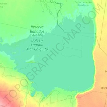
Name: Mar Chiquita topographic map, elevation, terrain.
Location: Mar Chiquita, Córdoba, Argentina (-30.95426 -63.36601 -30.12175 -62.18459)
Average elevation: 256 ft
Minimum elevation: 217 ft
Maximum elevation: 440 ft
Make a donation
Gear up for your next adventure:
As an Amazon Associate, this site earns from qualifying purchases at no extra cost to you.
Other topographic maps
Click on a map to view its topography, its elevation and its terrain.
Cordoba
Argentina > Córdoba > Pedanía Capital
The wealthier suburbs west of the city are located at slightly higher altitudes, which allows cool breezes to blow in the summer, bringing drier, comfortable nights during hotter periods, and more regular frost in the winter. Generally speaking, Córdoba's daytime temperatures are very slightly warmer than…
Average elevation: 1,499 ft
Observatorio Las Punillas
Argentina > Córdoba > Pedanía Alta Gracia > Alta Gracia
Average elevation: 1,857 ft
Make a donation
Gear up for your next adventure:
As an Amazon Associate, this site earns from qualifying purchases at no extra cost to you.
Make a donation
Gear up for your next adventure:
As an Amazon Associate, this site earns from qualifying purchases at no extra cost to you.
Make a donation
Gear up for your next adventure:
As an Amazon Associate, this site earns from qualifying purchases at no extra cost to you.
Falda del Carmen
Argentina > Córdoba > Pedanía Lagunilla > Falda del Carmen
Average elevation: 2,172 ft
Make a donation
Gear up for your next adventure:
As an Amazon Associate, this site earns from qualifying purchases at no extra cost to you.