
Make a donation
Gear up for your next adventure:
As an Amazon Associate, this site earns from qualifying purchases at no extra cost to you.
Hossana topographic map
Click on the map to display elevation.
Make a donation
Gear up for your next adventure:
As an Amazon Associate, this site earns from qualifying purchases at no extra cost to you.
Hossana
Hosaena, Hossana or Hosaina is a town which level as a woreda in southern Ethiopia, and currently serve as the administrative center of Hadiya Zone and Central Ethiopia Regional State as well. Geographically located to the central south of Ethiopia, with a latitude and longitude of 7°33′N 37°51′E / 7.550°N 37.850°E / 7.550; 37.850 with an elevation of 2177 meters above sea level. It was part of Limo woreda and is surrounded by it.
Make a donation
Gear up for your next adventure:
As an Amazon Associate, this site earns from qualifying purchases at no extra cost to you.
About this map
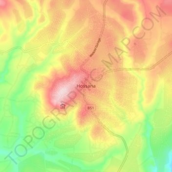
Name: Hossana topographic map, elevation, terrain.
Location: Hossana, Hadiya, Central Ethiopia Regional State, Ethiopia (7.51017 37.81282 7.59017 37.89282)
Average elevation: 7,398 ft
Minimum elevation: 6,890 ft
Maximum elevation: 7,871 ft
Make a donation
Gear up for your next adventure:
As an Amazon Associate, this site earns from qualifying purchases at no extra cost to you.
Other topographic maps
Click on a map to view its topography, its elevation and its terrain.