
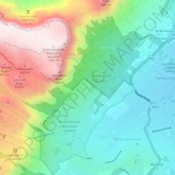
Kirstenbosch Botanical Gardens topographic map
Interactive map
Click on the map to display elevation.
About this map
Name: Kirstenbosch Botanical Gardens topographic map, elevation, terrain.
Average elevation: 1,273 ft
Minimum elevation: 98 ft
Maximum elevation: 3,547 ft
Other topographic maps
Click on a map to view its topography, its elevation and its terrain.
Chapman's Peak
RSA > Western Cape > Cape Town
Chapman's Peak, Cape Town, City of Cape Town, Western Cape, 7979, RSA
Average elevation: 423 ft
Constantiaberg
RSA > Western Cape > Cape Town
Constantiaberg, Cape Town, City of Cape Town, Western Cape, 7872, RSA
Average elevation: 1,614 ft
Tygerberg Nature Reserve
RSA > Western Cape > Cape Town
Tygerberg Nature Reserve, Peregrine, Plattekloof, Cape Town, City of Cape Town, Western Cape, 7500, RSA
Average elevation: 597 ft
Elsies Peak
RSA > Western Cape > Cape Town
Elsies Peak, Cape Town, City of Cape Town, Western Cape, 7975, RSA
Average elevation: 164 ft
Signal Hill
RSA > Western Cape > Cape Town
Signal Hill, Cape Town, City of Cape Town, Western Cape, 8018, RSA
Average elevation: 285 ft
Cape Town Ward 62
RSA > Western Cape > Cape Town
Cape Town Ward 62, Cape Town, City of Cape Town, Western Cape, RSA
Average elevation: 778 ft
Lion's Head
RSA > Western Cape > Cape Town
Lion's Head, Cape Town, City of Cape Town, Western Cape, 8005, RSA
Average elevation: 545 ft
Table Bay
RSA > Western Cape > Cape Town
Table Bay, Marine Drive, Paarden Eiland, Cape Town, City of Cape Town, Western Cape, 7405, RSA
Average elevation: 0 ft
Cape Town Ward 57
RSA > Western Cape > Cape Town
Cape Town Ward 57, Cape Town, City of Cape Town, Western Cape, RSA
Average elevation: 397 ft
Cape Town Ward 33
RSA > Western Cape > Cape Town
Cape Town Ward 33, Cape Town, City of Cape Town, Western Cape, RSA
Average elevation: 95 ft
Cape Town Ward 13
RSA > Western Cape > Cape Town
Cape Town Ward 13, Cape Town, City of Cape Town, Western Cape, RSA
Average elevation: 167 ft
Princess Vlei
RSA > Western Cape > Cape Town
Princess Vlei, Briana Road, Elfindale, Cape Town, City of Cape Town, Western Cape, 7945, RSA
Average elevation: 39 ft
Baviaanskloof River
RSA > Western Cape > Cape Town
Baviaanskloof River, Cape Town, City of Cape Town, Western Cape, 7872, RSA
Average elevation: 1,385 ft
Little Princess Vlei
RSA > Western Cape > Cape Town
Little Princess Vlei, Willowmere Road, Cape Town Ward 72, Cape Town, City of Cape Town, Western Cape, 7945, RSA
Average elevation: 43 ft
Diepsloot
RSA > Western Cape > Cape Town
Diepsloot, Cape Town, City of Cape Town, Western Cape, 8040, RSA
Average elevation: 308 ft