
San Miguel de Los Bancos topographic map
Interactive map
Click on the map to display elevation.
About this map
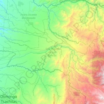
Name: San Miguel de Los Bancos topographic map, elevation, terrain.
Location: San Miguel de Los Bancos, Pichincha, Ecuador (-0.13745 -79.16933 0.09975 -78.64655)
Average elevation: 3,524 ft
Minimum elevation: 636 ft
Maximum elevation: 11,424 ft
Altitud: 550 a 1800 m s. n. m.
Other topographic maps
Click on a map to view its topography, its elevation and its terrain.
Quito
Ecuador > Pichincha > Distrito Metropolitano de Quito
Quito, Distrito Metropolitano de Quito, Pichincha, 170130, Ecuador
Average elevation: 9,613 ft
Refugio de Vida Silvestre y Bosque de Proteccion Pasochoa
Ecuador > Pichincha > Machachi > Tambillo
Refugio de Vida Silvestre y Bosque de Proteccion Pasochoa, Tambillo, Machachi, Pichincha, Ecuador
Average elevation: 10,633 ft
Mariscal Sucre
Mariscal Sucre, Pichincha, 1700, Ecuador
Average elevation: 8,488 ft