
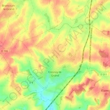
Fresnoy-le-Grand topographic map
Interactive map
Click on the map to display elevation.
About this map
Name: Fresnoy-le-Grand topographic map, elevation, terrain.
Average elevation: 433 ft
Minimum elevation: 308 ft
Maximum elevation: 522 ft
Other topographic maps
Click on a map to view its topography, its elevation and its terrain.
Iron
France > Hauts-de-France > Aisne
Iron, Vervins, Aisne, Hauts-de-France, Metropolitan France, 02510, France
Average elevation: 479 ft
Le Hérie-la-Viéville
France > Hauts-de-France > Aisne
Le Hérie-la-Viéville, Vervins, Aisne, Hauts-de-France, Metropolitan France, 02120, France
Average elevation: 377 ft
Étréaupont
France > Hauts-de-France > Aisne
Étréaupont, Vervins, Aisne, Hauts-de-France, Metropolitan France, 02580, France
Average elevation: 561 ft
Saint-Quentin
France > Hauts-de-France > Aisne
Saint-Quentin, Aisne, Hauts-de-France, Metropolitan France, 02100, France
Average elevation: 315 ft
Bagneux
France > Hauts-de-France > Aisne
Bagneux, Soissons, Aisne, Hauts-de-France, Metropolitan France, 02290, France
Average elevation: 407 ft
Parfondeval
France > Hauts-de-France > Aisne
Parfondeval, Vervins, Aisne, Hauts-de-France, Metropolitan France, 02360, France
Average elevation: 696 ft
Château-Thierry
France > Hauts-de-France > Aisne
Château-Thierry, Aisne, Hauts-de-France, Metropolitan France, 02400, France
Average elevation: 456 ft
Dohis
France > Hauts-de-France > Aisne
Dohis, Vervins, Aisne, Hauts-de-France, Metropolitan France, 02360, France
Average elevation: 702 ft
Lor
France > Hauts-de-France > Aisne
Lor, Laon, Aisne, Hauts-de-France, Metropolitan France, 02190, France
Average elevation: 325 ft
Sainte-Croix
France > Hauts-de-France > Aisne
Sainte-Croix, Laon, Aisne, Hauts-de-France, Metropolitan France, 02820, France
Average elevation: 449 ft
Castres
France > Hauts-de-France > Aisne
Castres, Saint-Quentin, Aisne, Hauts-de-France, Metropolitan France, 02680, France
Average elevation: 279 ft
Montcornet
France > Hauts-de-France > Aisne > Montcornet
Montcornet, Vervins, Aisne, Hauts-de-France, Metropolitan France, 02340, France
Average elevation: 453 ft
Saint-Quentin
France > Hauts-de-France > Aisne > Saint-Quentin > Saint-Quentin
Saint-Quentin, Aisne, Hauts-de-France, Metropolitan France, 02100, France
Average elevation: 325 ft
Gouy
France > Hauts-de-France > Aisne > Gouy
Gouy, Saint-Quentin, Aisne, Hauts-de-France, Metropolitan France, 02420, France
Average elevation: 397 ft
Montfaucon
France > Hauts-de-France > Aisne > Montfaucon
Montfaucon, Château-Thierry, Aisne, Hauts-de-France, Metropolitan France, 02540, France
Average elevation: 617 ft
Bruyères-et-Montbérault
France > Hauts-de-France > Aisne > Bruyères-et-Montbérault
Bruyères-et-Montbérault, Laon, Aisne, Hauts-de-France, Metropolitan France, 02860, France
Average elevation: 374 ft
Neuville-sur-Ailette
France > Hauts-de-France > Aisne > Neuville-sur-Ailette
Neuville-sur-Ailette, Laon, Aisne, Hauts-de-France, Metropolitan France, 02860, France
Average elevation: 354 ft
Soissons
France > Hauts-de-France > Aisne
Soissons, Aisne, Hauts-de-France, Metropolitan France, 02200, France
Average elevation: 194 ft
Saint-Thomas
France > Hauts-de-France > Aisne
Saint-Thomas, Laon, Aisne, Hauts-de-France, Metropolitan France, 02820, France
Average elevation: 486 ft
Martigny
France > Hauts-de-France > Aisne
Martigny, Vervins, Aisne, Hauts-de-France, Metropolitan France, 02500, France
Average elevation: 636 ft
Mont-Saint-Jean
France > Hauts-de-France > Aisne
Mont-Saint-Jean, Vervins, Aisne, Hauts-de-France, Metropolitan France, 02360, France
Average elevation: 774 ft
Saint-Michel
France > Hauts-de-France > Aisne
Saint-Michel, Vervins, Aisne, Hauts-de-France, Metropolitan France, 02830, France
Average elevation: 741 ft
Brécy
France > Hauts-de-France > Aisne
Brécy, Château-Thierry, Aisne, Hauts-de-France, Metropolitan France, 02210, France
Average elevation: 522 ft
Cœuvres-et-Valsery
France > Hauts-de-France > Aisne
Cœuvres-et-Valsery, Soissons, Aisne, Hauts-de-France, Metropolitan France, 02600, France
Average elevation: 410 ft
Belleau
France > Hauts-de-France > Aisne
Belleau, Château-Thierry, Aisne, Hauts-de-France, Metropolitan France, 02400, France
Average elevation: 449 ft
Coucy-le-Château-Auffrique
France > Hauts-de-France > Aisne
Coucy-le-Château-Auffrique, Laon, Aisne, Hauts-de-France, Metropolitan France, 02380, France
Average elevation: 236 ft
Laon
France > Hauts-de-France > Aisne
Laon, Aisne, Hauts-de-France, Metropolitan France, 02000, France
Average elevation: 256 ft
Guise
France > Hauts-de-France > Aisne
Guise, Vervins, Aisne, Hauts-de-France, Metropolitan France, 02120, France
Average elevation: 427 ft
Hirson
France > Hauts-de-France > Aisne
Hirson, Vervins, Aisne, Hauts-de-France, Metropolitan France, 02500, France
Average elevation: 679 ft
Essômes-sur-Marne
France > Hauts-de-France > Aisne
Essômes-sur-Marne, Château-Thierry, Aisne, Hauts-de-France, Metropolitan France, 02400, France
Average elevation: 436 ft
Bouresches
France > Hauts-de-France > Aisne
Bouresches, Château-Thierry, Aisne, Hauts-de-France, Metropolitan France, 02400, France
Average elevation: 531 ft