
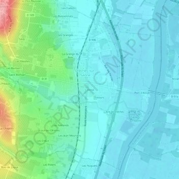
L'Orme topographic map
Interactive map
Click on the map to display elevation.
About this map
Name: L'Orme topographic map, elevation, terrain.
Average elevation: 623 ft
Minimum elevation: 548 ft
Maximum elevation: 932 ft
Other topographic maps
Click on a map to view its topography, its elevation and its terrain.
La Brancionne
France > Bourgogne-Franche-Comté > Saône-et-Loire > Crêches-sur-Saône
La Brancionne, Crêches-sur-Saône, Mâcon, Saône-et-Loire, Bourgogne-Franche-Comté, France métropolitaine, 71680, France
Average elevation: 633 ft
Estours
France > Bourgogne-Franche-Comté > Saône-et-Loire > Crêches-sur-Saône
Estours, Crêches-sur-Saône, Mâcon, Saône-et-Loire, Bourgogne-Franche-Comté, France métropolitaine, 71680, France
Average elevation: 610 ft
La Grange du Bois
France > Bourgogne-Franche-Comté > Saône-et-Loire > Crêches-sur-Saône
La Grange du Bois, Crêches-sur-Saône, Mâcon, Saône-et-Loire, Bourgogne-Franche-Comté, France métropolitaine, 71680, France
Average elevation: 653 ft