Geolocate

Penida Island topographic map

Click on the map to display elevation.

Penida Island

Nusa Penida (Balinese: ᬦᬸᬲᬧᭂᬦᬶᬤ, romanized: nusa pĕnida) is an island located near the southeastern Indonesian island of Bali, which forms a district of the same name in Klungkung Regency. The Badung Strait separates the island and Bali. The interior of Nusa Penida is hilly with a maximum altitude of 524 metres, and the climate is drier than Bali. Like Bali, it is a major tourist destination.

Wikipedia (CC-BY-SA 3.0)

About this map

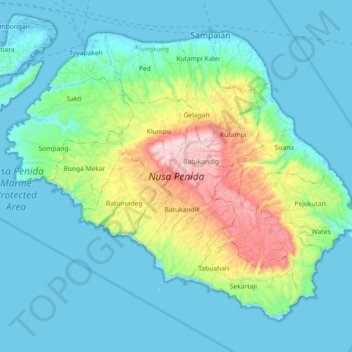
Name: Penida Island topographic map, elevation, terrain.

Location: Penida Island, Nusa Penida, Klungkung Regency, Bali, Lesser Sunda Islands, Indonesia (-8.81950 115.44670 -8.67170 115.62855)

Average elevation: 341 ft

Minimum elevation: -13 ft

Maximum elevation: 1,696 ft

Gear up for your next adventure:

🪶Camping Sleeping Pad - Comfortable sleeping pad for backpacking
🪶Trail Camera - Capture wildlife on your hikes
🏕️Family Camping Gear - Essentials for group camping trips
🧥Men's Rain Shells - Premium waterproof and breathable jackets for mountain weather
🔋Solar Power Banks - Keep your GPS and phone charged in remote wilderness areas

As an Amazon Associate, this site earns from qualifying purchases at no extra cost to you.