
Cádiz topographic map
Interactive map
Click on the map to display elevation.
About this map
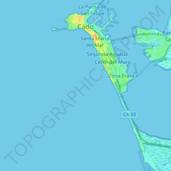
Name: Cádiz topographic map, elevation, terrain.
Location: Cádiz, Bahía de Cádiz, Cádiz, Andalusia, Spagna (36.44379 -6.31746 36.54546 -6.22506)
Average elevation: 3 ft
Minimum elevation: -26 ft
Maximum elevation: 105 ft
Other topographic maps
Click on a map to view its topography, its elevation and its terrain.
Chiclana de la Frontera
Spagna > Andalusia > Bahía de Cádiz
Chiclana de la Frontera, Bahía de Cádiz, Cádiz, Andalusia, Spagna
Average elevation: 79 ft