
Bellis Island topographic map
Interactive map
Click on the map to display elevation.
About this map
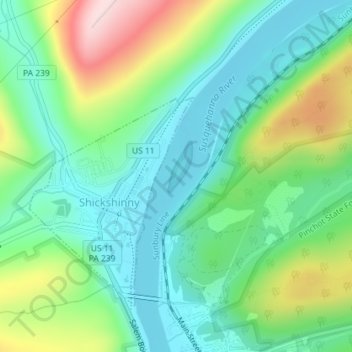
Name: Bellis Island topographic map, elevation, terrain.
Average elevation: 794 ft
Minimum elevation: 472 ft
Maximum elevation: 1,516 ft
Other topographic maps
Click on a map to view its topography, its elevation and its terrain.
Winfield Township
Estados Unidos de América > Pensilvania > Winfield Township
Winfield Township, Butler County, Pensilvania, 16023, Estados Unidos de América
Average elevation: 1,260 ft
Congo
Estados Unidos de América > Pensilvania > Congo
Congo, Montgomery County, Pensilvania, 19472, Estados Unidos de América
Average elevation: 404 ft