
Wainuiomata River topographic map
Interactive map
Click on the map to display elevation.
About this map
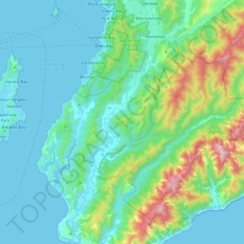
Name: Wainuiomata River topographic map, elevation, terrain.
Average elevation: 594 ft
Minimum elevation: -7 ft
Maximum elevation: 2,972 ft
Other topographic maps
Click on a map to view its topography, its elevation and its terrain.
Lower Hutt
New Zealand > Wellington > Lower Hutt City
Lower Hutt, Lower Hutt City, Wellington, 5040, New Zealand
Average elevation: 568 ft
Hutt Valley
New Zealand > Wellington > Lower Hutt City > Lower Hutt
Hutt Valley, Lower Hutt, Lower Hutt City, Wellington, New Zealand
Average elevation: 696 ft
Waimarama
New Zealand > Wellington > Lower Hutt City
Waimarama, Lower Hutt City, Wellington, New Zealand
Average elevation: 699 ft
Ōrongorongo River
New Zealand > Wellington > Lower Hutt City
Ōrongorongo River, Lower Hutt City, Wellington, New Zealand
Average elevation: 778 ft