Geolocate

Enoggera topographic map

Click on the map to display elevation.

About this map

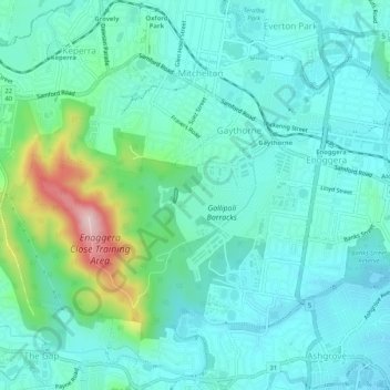
Name: Enoggera topographic map, elevation, terrain.

Location: Enoggera, Brisbane City, Queensland, Australia (-27.44232 152.94836 -27.41063 153.00028)

Average elevation: 213 ft

Minimum elevation: 36 ft

Maximum elevation: 919 ft

Other topographic maps

Click on a map to view its topography, its elevation and its terrain.

Willmington Park

Australia > Queensland > Brisbane City

Average elevation: 121 ft

Mount Gravatt

Australia > Queensland > Brisbane City

Average elevation: 230 ft

Ithaca

Australia > Queensland > Brisbane City > Ithaca

Average elevation: 102 ft

Gear up for your next adventure:

🧭Map Reading Tools - Tools and kits for map navigation
🗺️Topographic Maps - Detailed topo maps for hiking, exploring and outdoor navigation
🧭Hiking Compass - Precision compass for reliable navigation in the wilderness
🏕️Family Camping Gear - Essentials for group camping trips
🥘Titanium Cookware - Durable, featherlight pots and pans for backpacking

As an Amazon Associate, this site earns from qualifying purchases at no extra cost to you.