
Make a donation
Gear up for your next adventure:
As an Amazon Associate, this site earns from qualifying purchases at no extra cost to you.
Chosica topographic map
Click on the map to display elevation.
Make a donation
Gear up for your next adventure:
As an Amazon Associate, this site earns from qualifying purchases at no extra cost to you.
About this map
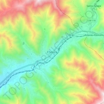
Name: Chosica topographic map, elevation, terrain.
Location: Chosica, Lima Metropolitan Area, Lima, 15468, Peru (-11.97677 -76.73691 -11.89677 -76.65691)
Average elevation: 4,163 ft
Minimum elevation: 2,369 ft
Maximum elevation: 7,195 ft
Make a donation
Gear up for your next adventure:
As an Amazon Associate, this site earns from qualifying purchases at no extra cost to you.
Other topographic maps
Click on a map to view its topography, its elevation and its terrain.
Surquillo
Since the beginning of the 2000s and the beginning of the 2010s, and to a greater extent today, there has been a considerable real estate boom within Surquillo, in which many residential real estate companies have invested in new residential building projects in several points of the district due to the…
Average elevation: 394 ft
Make a donation
Gear up for your next adventure:
As an Amazon Associate, this site earns from qualifying purchases at no extra cost to you.
Cordillera Huayhuash
The area preserves high elevation Andean grasslands and patches of forest. Some of the native tree species present in the area are the Andean alder and trees of the genus Polylepis.
Average elevation: 15,833 ft
Make a donation
Gear up for your next adventure:
As an Amazon Associate, this site earns from qualifying purchases at no extra cost to you.
Make a donation
Gear up for your next adventure:
As an Amazon Associate, this site earns from qualifying purchases at no extra cost to you.
Rímac River
The Rímac River begins its journey on the western slope of the Andes mountain range at an altitude of approximately 5,508 mamsl in the Nevado Paca, touring the provinces of Lima and Huarochirí, both located in the department of Lima. Among the most important tributaries of the Rímac are the Santa Eulalia…
Average elevation: 9,117 ft
Make a donation
Gear up for your next adventure:
As an Amazon Associate, this site earns from qualifying purchases at no extra cost to you.
Los Pantanos de Villa Wildlife Refuge
Pantanos de Villa Wildlife Refuge consists of a series of brackish water lagoons and marshes. These wetlands are formed by the filtration and discharge of water from the Ate-Surco-Chorrillos irrigation canal (which branches off from the Rimac River) and other underground canals. Elevational range inside the…
Average elevation: 36 ft
Make a donation
Gear up for your next adventure:
As an Amazon Associate, this site earns from qualifying purchases at no extra cost to you.
Make a donation
Gear up for your next adventure:
As an Amazon Associate, this site earns from qualifying purchases at no extra cost to you.
Make a donation
Gear up for your next adventure:
As an Amazon Associate, this site earns from qualifying purchases at no extra cost to you.
Make a donation
Gear up for your next adventure:
As an Amazon Associate, this site earns from qualifying purchases at no extra cost to you.
Pachacámac
Peru > Lima > Santa Anita
The district is located in the southern part of the Lima province at an elevation of 75m.
Average elevation: 1,450 ft
Make a donation
Gear up for your next adventure:
As an Amazon Associate, this site earns from qualifying purchases at no extra cost to you.
Make a donation
Gear up for your next adventure:
As an Amazon Associate, this site earns from qualifying purchases at no extra cost to you.
Make a donation
Gear up for your next adventure:
As an Amazon Associate, this site earns from qualifying purchases at no extra cost to you.
Make a donation
Gear up for your next adventure:
As an Amazon Associate, this site earns from qualifying purchases at no extra cost to you.
Make a donation
Gear up for your next adventure:
As an Amazon Associate, this site earns from qualifying purchases at no extra cost to you.
Make a donation
Gear up for your next adventure:
As an Amazon Associate, this site earns from qualifying purchases at no extra cost to you.
Make a donation
Gear up for your next adventure:
As an Amazon Associate, this site earns from qualifying purchases at no extra cost to you.
Surquillo
Since the beginning of the 2000s and the beginning of the 2010s, and to a greater extent today, there has been a considerable real estate boom within Surquillo, in which many residential real estate companies have invested in new residential building projects in several points of the district due to the…
Average elevation: 387 ft
Make a donation
Gear up for your next adventure:
As an Amazon Associate, this site earns from qualifying purchases at no extra cost to you.
Make a donation
Gear up for your next adventure:
As an Amazon Associate, this site earns from qualifying purchases at no extra cost to you.
Make a donation
Gear up for your next adventure:
As an Amazon Associate, this site earns from qualifying purchases at no extra cost to you.
Make a donation
Gear up for your next adventure:
As an Amazon Associate, this site earns from qualifying purchases at no extra cost to you.
Make a donation
Gear up for your next adventure:
As an Amazon Associate, this site earns from qualifying purchases at no extra cost to you.
Make a donation
Gear up for your next adventure:
As an Amazon Associate, this site earns from qualifying purchases at no extra cost to you.
Make a donation
Gear up for your next adventure:
As an Amazon Associate, this site earns from qualifying purchases at no extra cost to you.
Make a donation
Gear up for your next adventure:
As an Amazon Associate, this site earns from qualifying purchases at no extra cost to you.
Make a donation
Gear up for your next adventure:
As an Amazon Associate, this site earns from qualifying purchases at no extra cost to you.
Carabayllo
Carabayllo was the first district to be created by decree in the Lima Province by General José de San Martín in the independence era on August 4, 1821. At that time the district occupied the whole Chillón valley north of the Rímac River up to the Canta province. In principle, the district was the only one…
Average elevation: 2,625 ft
Make a donation
Gear up for your next adventure:
As an Amazon Associate, this site earns from qualifying purchases at no extra cost to you.