
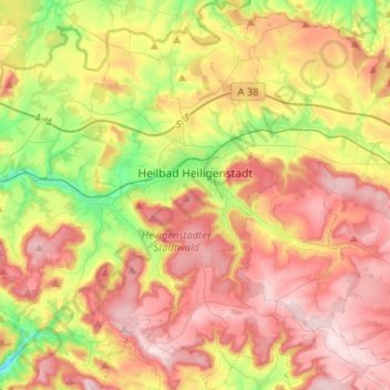
Heilbad Heiligenstadt topographic map
Interactive map
Click on the map to display elevation.
About this map
Name: Heilbad Heiligenstadt topographic map, elevation, terrain.
Average elevation: 1,198 ft
Minimum elevation: 656 ft
Maximum elevation: 1,709 ft
Other topographic maps
Click on a map to view its topography, its elevation and its terrain.
Kella
Germany > Thuringia > Landkreis Eichsfeld
Kella, Ershausen/Geismar, Landkreis Eichsfeld, Thuringia, Germany
Average elevation: 1,184 ft
Leinefelde
Germany > Thuringia > Landkreis Eichsfeld > Leinefelde-Worbis
Leinefelde, Leinefelde-Worbis, Landkreis Eichsfeld, Thuringia, 37327, Germany
Average elevation: 1,181 ft
Dietzenrode/Vatterode
Germany > Thuringia > Landkreis Eichsfeld
Dietzenrode/Vatterode, Uder, Landkreis Eichsfeld, Thuringia, Germany
Average elevation: 991 ft
Ferna
Germany > Thuringia > Landkreis Eichsfeld
Ferna, Lindenberg/Eichsfeld, Landkreis Eichsfeld, Thuringia, Germany
Average elevation: 965 ft
Walse
Germany > Thuringia > Landkreis Eichsfeld > Dietzenrode/Vatterode
Walse, Dietzenrode, Dietzenrode/Vatterode, Uder, Landkreis Eichsfeld, Thuringia, 37318, Germany
Average elevation: 988 ft
Geismar
Germany > Thuringia > Landkreis Eichsfeld
Geismar, Ershausen/Geismar, Landkreis Eichsfeld, Thuringia, Germany
Average elevation: 958 ft