
The Timp topographic map
Interactive map
Click on the map to display elevation.
About this map
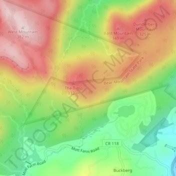
Name: The Timp topographic map, elevation, terrain.
Average elevation: 666 ft
Minimum elevation: 85 ft
Maximum elevation: 1,247 ft
Other topographic maps
Click on a map to view its topography, its elevation and its terrain.
Buckberg
Vereinigte Staaten von Amerika > New York > Rockland County > Town of Stony Point
Buckberg, Town of Stony Point, Rockland County, New York, 10986, Vereinigte Staaten von Amerika
Average elevation: 354 ft