
Hokianga Harbour topographic map
Interactive map
Click on the map to display elevation.
About this map
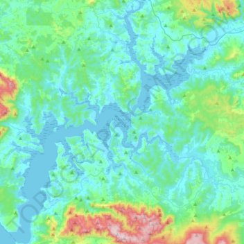
Name: Hokianga Harbour topographic map, elevation, terrain.
Average elevation: 371 ft
Minimum elevation: -3 ft
Maximum elevation: 2,477 ft
Other topographic maps
Click on a map to view its topography, its elevation and its terrain.
Whatuwhiwhi
New Zealand > Far North District > Te Hiku Community > Whatuwhiwhi
Whatuwhiwhi, Te Hiku Community, Far North District, Northland, New Zealand
Average elevation: 59 ft
Whakawhiti Stream
New Zealand > Far North District > Bay of Islands-Whangaroa Community > Manawaora
Whakawhiti Stream, Manawaora, Bay of Islands-Whangaroa Community, Far North District, Northland, New Zealand
Average elevation: 190 ft