
Höchstadt a.d.Aisch topographic map
Interactive map
Click on the map to display elevation.
About this map
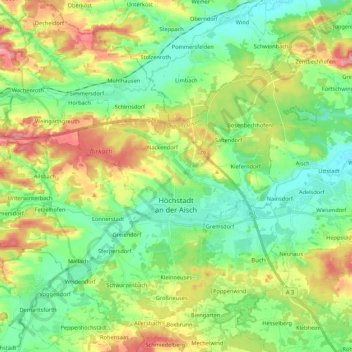
Name: Höchstadt a.d.Aisch topographic map, elevation, terrain.
Average elevation: 978 ft
Minimum elevation: 843 ft
Maximum elevation: 1,217 ft
Other topographic maps
Click on a map to view its topography, its elevation and its terrain.
Herzogenaurach
Germany > Bavaria > Landkreis Erlangen-Höchstadt > Herzogenaurach
Herzogenaurach, Landkreis Erlangen-Höchstadt, Bavaria, 91074, Germany
Average elevation: 1,079 ft