Geolocate

Biddenden topographic map

Click on the map to display elevation.

About this map

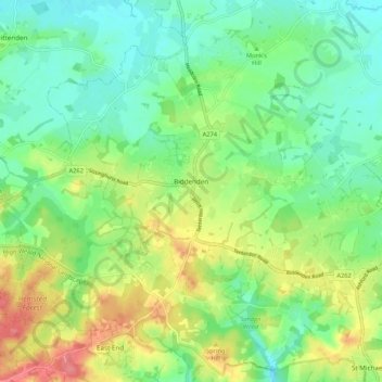
Name: Biddenden topographic map, elevation, terrain.

Location: Biddenden, Ashford, Kent, England, United Kingdom (51.08277 0.59030 51.14457 0.69628)

Average elevation: 151 ft

Minimum elevation: 62 ft

Maximum elevation: 305 ft

Other topographic maps

Click on a map to view its topography, its elevation and its terrain.

Hamstreet

United Kingdom > England > Kent > Ashford

Average elevation: 72 ft

Hinxhill

United Kingdom > England > Kent > Ashford

Average elevation: 167 ft

Gear up for your next adventure:

📻Weather Alert Radios - Stay informed of storm risks while off-the-grid
🎒Waterproof Dry Bags - Keep your electronics and maps dry inside your pack
🚪Portable Camp Chair - Foldable chair for comfort at camp
🔥Camping Stove - Portable stove for camping and backcountry cooking
🪶Fire Starter Kit - Reliable fire starter for survival and camping

As an Amazon Associate, this site earns from qualifying purchases at no extra cost to you.