
Make a donation
Gear up for your next adventure:
As an Amazon Associate, this site earns from qualifying purchases at no extra cost to you.
Orotina topographic map
Click on the map to display elevation.
Make a donation
Gear up for your next adventure:
As an Amazon Associate, this site earns from qualifying purchases at no extra cost to you.
Orotina
Orotina has an area of 21.59 km2 and an elevation of 229 metres. It is in a relatively flat section on the west side of the coastal mountain range of Costa Rica, It is 26 kilometers northeast of the Pacific Ocean at Tárcoles, 48 kilometers southwest of the provincial capital city of Alajuela, and 66 kilometers from the national capital city of San Jose.
Make a donation
Gear up for your next adventure:
As an Amazon Associate, this site earns from qualifying purchases at no extra cost to you.
About this map
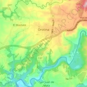
Name: Orotina topographic map, elevation, terrain.
Location: Orotina, Alajuela Province, 20901, Costa Rica (9.87248 -84.54858 9.93223 -84.50147)
Average elevation: 548 ft
Minimum elevation: 128 ft
Maximum elevation: 1,191 ft
Make a donation
Gear up for your next adventure:
As an Amazon Associate, this site earns from qualifying purchases at no extra cost to you.