
Burr Oak topographic map
Interactive map
Click on the map to display elevation.
About this map
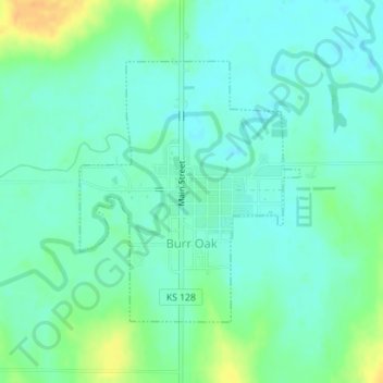
Name: Burr Oak topographic map, elevation, terrain.
Location: Burr Oak, Jewell County, Kansas, 66936, United States (39.86055 -98.31534 39.87896 -98.29512)
Average elevation: 1,673 ft
Minimum elevation: 1,640 ft
Maximum elevation: 1,745 ft
Other topographic maps
Click on a map to view its topography, its elevation and its terrain.
Lovewell
United States > Kansas > Jewell County > Lovewell
Lovewell, Jewell County, Kansas, United States
Average elevation: 1,591 ft
Mankato
United States > Kansas > Jewell County
Mankato, Jewell County, Kansas, United States
Average elevation: 1,768 ft