
Sulz am Neckar topographic map
Interactive map
Click on the map to display elevation.
About this map
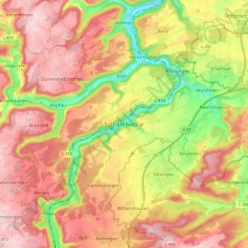
Name: Sulz am Neckar topographic map, elevation, terrain.
Average elevation: 1,831 ft
Minimum elevation: 1,286 ft
Maximum elevation: 2,280 ft
Other topographic maps
Click on a map to view its topography, its elevation and its terrain.
Mühlheim
Duitsland > Baden-Württemberg > Landkreis Rottweil > Sulz am Neckar
Mühlheim, Sulz am Neckar, Verwaltungsgemeinschaft Sulz am Neckar, Landkreis Rottweil, Baden-Württemberg, 72172, Duitsland
Average elevation: 1,604 ft