
Vaugelan topographic map
Interactive map
Click on the map to display elevation.
About this map
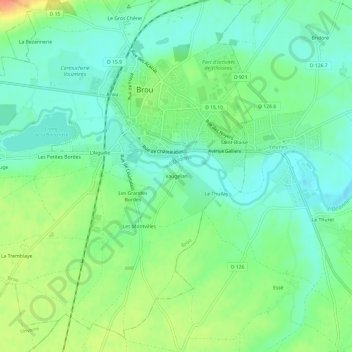
Name: Vaugelan topographic map, elevation, terrain.
Average elevation: 528 ft
Minimum elevation: 472 ft
Maximum elevation: 627 ft
Other topographic maps
Click on a map to view its topography, its elevation and its terrain.
Le Gros Chêne
France > Centre-Val de Loire > Eure-et-Loir > Brou
Le Gros Chêne, Brou, Châteaudun, Eure-et-Loir, Centre-Val de Loire, France métropolitaine, 28160, France
Average elevation: 558 ft
Saint-Blaise
France > Centre-Val de Loire > Eure-et-Loir > Brou
Saint-Blaise, Brou, Châteaudun, Eure-et-Loir, Centre-Val de Loire, France métropolitaine, 28160, France
Average elevation: 525 ft