
Make a donation
Gear up for your next adventure:
As an Amazon Associate, this site earns from qualifying purchases at no extra cost to you.
Les Agettes topographic map
Click on the map to display elevation.
Make a donation
Gear up for your next adventure:
As an Amazon Associate, this site earns from qualifying purchases at no extra cost to you.
Les Agettes
The former municipality was located in the Hérens district, on the slopes south of Sion and above the Rhone valley. It is composed of three small villages: Crête-à-l'Œil, La Vernaz, and Les Agettes, which range in altitude between 980 and 1,200 m (3,220 and 3,940 ft) as well as scattered alpine pastures and the vacation resort of Mayens de l'Ours (built in 1982).
Make a donation
Gear up for your next adventure:
As an Amazon Associate, this site earns from qualifying purchases at no extra cost to you.
About this map
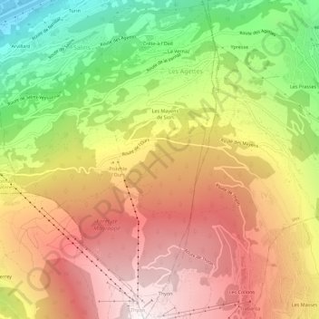
Name: Les Agettes topographic map, elevation, terrain.
Location: Les Agettes, Sion, Wallis, 1992, Switzerland (46.17805 7.34521 46.21673 7.38059)
Average elevation: 4,577 ft
Minimum elevation: 1,588 ft
Maximum elevation: 7,149 ft
Make a donation
Gear up for your next adventure:
As an Amazon Associate, this site earns from qualifying purchases at no extra cost to you.