
Make a donation
Gear up for your next adventure:
As an Amazon Associate, this site earns from qualifying purchases at no extra cost to you.
Ilartzi/Ghilarza topographic map
Click on the map to display elevation.
Make a donation
Gear up for your next adventure:
As an Amazon Associate, this site earns from qualifying purchases at no extra cost to you.
About this map
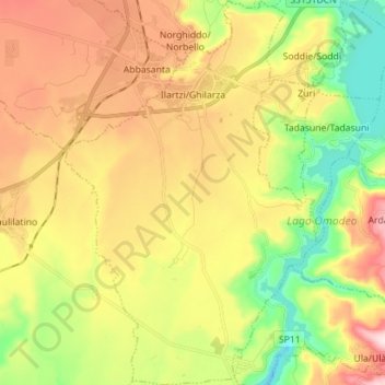
Name: Ilartzi/Ghilarza topographic map, elevation, terrain.
Location: Ilartzi/Ghilarza, Aristanis/Oristano, Sardinia, 09074, Italy (40.03846 8.78815 40.14605 8.91092)
Average elevation: 801 ft
Minimum elevation: 194 ft
Maximum elevation: 1,512 ft
Make a donation
Gear up for your next adventure:
As an Amazon Associate, this site earns from qualifying purchases at no extra cost to you.
Other topographic maps
Click on a map to view its topography, its elevation and its terrain.
Spiaggia della Balena
Italy > Sardinia > Aristanis/Oristano > Cùllieri/Cuglieri > Torre del Pozzo
Average elevation: 102 ft
Make a donation
Gear up for your next adventure:
As an Amazon Associate, this site earns from qualifying purchases at no extra cost to you.