
Thank you for supporting this site ❤️
Make a donation
Make a donation
Gear up for your next adventure:
As an Amazon Associate, this site earns from qualifying purchases at no extra cost to you.
Curanilahue topographic map
Click on the map to display elevation.
Thank you for supporting this site ❤️
Make a donation
Make a donation
Gear up for your next adventure:
As an Amazon Associate, this site earns from qualifying purchases at no extra cost to you.
About this map
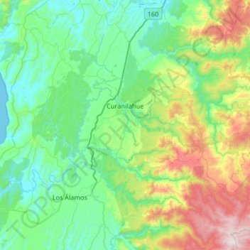
Name: Curanilahue topographic map, elevation, terrain.
Location: Curanilahue, Provincia de Arauco, Biobio Region, Chile (-37.68770 -73.50555 -37.32864 -72.98115)
Average elevation: 1,030 ft
Minimum elevation: 0 ft
Maximum elevation: 4,511 ft
Thank you for supporting this site ❤️
Make a donation
Make a donation
Gear up for your next adventure:
As an Amazon Associate, this site earns from qualifying purchases at no extra cost to you.