
Make a donation
Gear up for your next adventure:
As an Amazon Associate, this site earns from qualifying purchases at no extra cost to you.
Parque Industrial topographic map
Click on the map to display elevation.
Make a donation
Gear up for your next adventure:
As an Amazon Associate, this site earns from qualifying purchases at no extra cost to you.
About this map
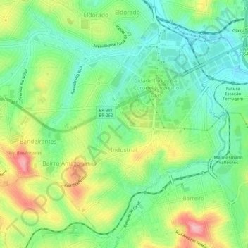
Name: Parque Industrial topographic map, elevation, terrain.
Average elevation: 3,091 ft
Minimum elevation: 2,897 ft
Maximum elevation: 3,422 ft
Make a donation
Gear up for your next adventure:
As an Amazon Associate, this site earns from qualifying purchases at no extra cost to you.
Other topographic maps
Click on a map to view its topography, its elevation and its terrain.
Contagem
Brazil > Minas Gerais > Região Metropolitana de Belo Horizonte > Contagem
The city belongs to the metropolitan mesoregion and to the microregion of Belo Horizonte, has a territorial extension of 195.2 square kilometres (75.4 square miles), and borders the municipalities of Ribeirão das Neves, Esmeraldas, Betim, Ibirité and Belo Horizonte. The elevation of the city hall is 939…
Average elevation: 2,920 ft