
Parque Nacional Ciervo de Los Pantanos topographic map
Interactive map
Click on the map to display elevation.
About this map
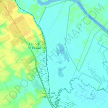
Name: Parque Nacional Ciervo de Los Pantanos topographic map, elevation, terrain.
Average elevation: 26 ft
Minimum elevation: -16 ft
Maximum elevation: 125 ft
Other topographic maps
Click on a map to view its topography, its elevation and its terrain.
Reserva Natural Otamendi
Argentina > Buenos Aires > Lomas del Río Luján
Reserva Natural Otamendi, Manuel Sarratea, San Jacinto, Las Colinas de Otamendi, Lomas del Río Luján, Partido de Campana, Buenos Aires, Argentina
Average elevation: 26 ft