
Hürbel topographic map
Click on the map to display elevation.
About this map
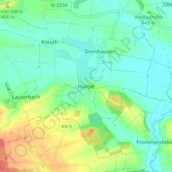
Name: Hürbel topographic map, elevation, terrain.
Average elevation: 1,453 ft
Minimum elevation: 1,394 ft
Maximum elevation: 1,588 ft
Other topographic maps
Click on a map to view its topography, its elevation and its terrain.
Buch am Wald
Deutschland > Bayern > Landkreis Ansbach
Die Gemeinde liegt im Naturpark Frankenhöhe. Nachbargemeinden sind (im Norden beginnend im Uhrzeigersinn): Geslau, Leutershausen, Schillingsfürst und Gebsattel.
Average elevation: 1,496 ft
Rothenburg ob der Tauber
Deutschland > Bayern > Landkreis Ansbach
Von 1274 bis 1803 war Rothenburg eine Reichsstadt. Nach dem Dreißigjährigen Krieg verlor die Stadt an Bedeutung. Sie blieb zwar das Zentrum eines ausgedehnten Landgebiets und ein kultureller Mittelpunkt, entwickelte sich aber nur allmählich weiter, wodurch das alte Stadtbild überwiegend erhalten blieb. Im…
Average elevation: 1,375 ft
Dinkelsbühl
Deutschland > Bayern > Landkreis Ansbach
Dinkelsbühl liegt nahe der Grenze zu Baden-Württemberg. Die Stadt liegt an der Wörnitz im Südosten der Frankenhöhe, die im Südwestdeutschen Schichtstufenland zwischen Main und Donau zur Keuperstufe gehört. Durch eine östlich des heutigen Laufes liegende Burgsandsteinkuppe nach Westen abgedrängt,…
Average elevation: 1,555 ft
Feuchtwangen
Deutschland > Bayern > Landkreis Ansbach
Geographisch und geologisch liegt Feuchtwangen auf der Frankenhöhe, einem Teil des Schwäbisch-Fränkischen Schichtstufenlandes, das auch als Gips-Keuper-Landschaft bezeichnet wird. Charakteristisch für diese Landschaft ist der durch die geringe Widerstandskraft der Keuperschichten entstandene schnelle…
Average elevation: 1,558 ft
Kleiner Lindleinsee
Deutschland > Bayern > Landkreis Ansbach > Rothenburg ob der Tauber
Average elevation: 1,339 ft
Dombühl
Deutschland > Bayern > Landkreis Ansbach
Die Gemeinde liegt im Naturpark Frankenhöhe. Dombühl ist Bahnstation an der Strecke Heilbronn – Nürnberg zwischen den Knotenbahnhöfen Crailsheim und Ansbach.
Average elevation: 1,594 ft
Neusitz
Deutschland > Bayern > Landkreis Ansbach
Das Gemeindegebiet zieht sich am bewaldeten Westabhang der Frankenhöhe und an deren Hangfuß auf der offenen östlichen Hohenloher Ebene etwa 6,5 km weit von Norden nach Süden. Es liegt zur Gänze im Naturpark Frankenhöhe. Nur ein sehr kleiner Flächenanteil der Gemeinde an ihrem Ostsaum liegt auf dem hier…
Average elevation: 1,414 ft
Diebach
Deutschland > Bayern > Landkreis Ansbach
Die Gemeinde liegt südlich von Rothenburg ob der Tauber am Westabfall der Frankenhöhe ins Tal der oberen Tauber, der namengebende Hauptort an der Mündung des rechten Wohnbachs in den noch kleinen Fluss.
Average elevation: 1,391 ft
Oberdachstetten
Deutschland > Bayern > Landkreis Ansbach
Oberdachstetten liegt am nördlichen Rand des Landkreises Ansbach an der Fränkischen Rezat. Im Gemeindegebiet gibt es Anhöhen bis 534 m ü. NHN, die zur Frankenhöhe zählen.
Average elevation: 1,493 ft
Schillingsfürst
Deutschland > Bayern > Landkreis Ansbach
Die Stadt Schillingsfürst liegt im Naturpark Frankenhöhe.
Average elevation: 1,549 ft
Dürrwangen
Deutschland > Bayern > Landkreis Ansbach
Der Hauptort liegt im südwestlichen Landkreis Ansbach nahe der Großen Kreisstadt Dinkelsbühl und der Stadt Feuchtwangen (jeweils 8 km entfernt). Das Gemeindegebiet befindet sich größtenteils auf dem Höhenzug zwischen den Tälern der Flüsse Wörnitz und Sulzach sowie im Sulzachtal westlich des Flusses.…
Average elevation: 1,539 ft
Wettringen
Deutschland > Bayern > Landkreis Ansbach
Die Gemeinde liegt ca. 30 Kilometer westlich von Ansbach im Naturpark Frankenhöhe.
Average elevation: 1,483 ft
Wittelshofen
Deutschland > Bayern > Landkreis Ansbach
Wittelshofen ist Ausgangspunkt des geologischen Wanderpfades, der auf die Höhen des Hesselberges führt. An seinem Anfang liegt eine der wenigen Ölschiefergruben in Deutschland, die immer wieder das Ziel von Geologen ist. An Sulzach und Wörnitz brüten noch Kiebitz und Bekassine und der Storch hat auf dem…
Average elevation: 1,532 ft
Merkendorf
Deutschland > Bayern > Landkreis Ansbach
Die Mannschaften des TSV Merkendorf spielen im Kreis Nürnberg/Frankenhöhe, die Schützengruppen des SV Merkendorf im Schützengau Hesselberg.
Average elevation: 1,437 ft
Wörnitz
Deutschland > Bayern > Landkreis Ansbach
Wörnitz liegt im Naturpark Frankenhöhe; durch das Gemeindegebiet fließt die Wörnitz.
Average elevation: 1,578 ft
Schnelldorf
Deutschland > Bayern > Landkreis Ansbach
Schnelldorf liegt im Gebiet der Frankenhöhe rund 2 km südsüdöstlich des Birkenbergs, etwas mehr als 4 km (Luftlinie) westlich des Autobahnkreuzes Feuchtwangen/Crailsheim und wird von einem Oberlaufabschnitt der Ampfrach (einem westlichen Wörnitz-Zufluss) durchflossen.
Average elevation: 1,565 ft
Aurach
Deutschland > Bayern > Landkreis Ansbach
Die Gemeinde liegt zwischen Altmühl und Frankenhöhe etwa auf halbem Weg von Ansbach nach Feuchtwangen. Das Gemeindegebiet reicht im Osten teilweise bis ans Ufer der Altmühl und erstreckt sich westwärts übers Quellgebiet der Wieseth bis wenig jenseits der Sulzach.
Average elevation: 1,503 ft
Geslau
Deutschland > Bayern > Landkreis Ansbach
Geslau liegt im Naturpark Frankenhöhe etwa 10 km östlich von Rothenburg ob der Tauber. Durch die Gemeinde fließt der Kreuthbach.
Average elevation: 1,506 ft
Wassertrüdingen
Deutschland > Bayern > Landkreis Ansbach
Das ehemalige Markgrafenstädtchen Wassertrüdingen liegt oberhalb von 420 m ü. NHN an der aus dem Westen in breitem Tal heranziehenden Wörnitz, die hier von Norden den Lentersheimer Mühlbach aufnimmt und dann nach Süden abknickt. In westnordwestlicher Richtung erstreckt sich von der Stadt aus über mehr…
Average elevation: 1,526 ft
Dietenhofen
Deutschland > Bayern > Landkreis Ansbach
Die Gemeinde liegt im Naturpark Frankenhöhe etwa 28 km westlich von Nürnberg, 14 km nordöstlich von Ansbach und 38 km östlich von Rothenburg ob der Tauber. Durch den Ort fließt die Bibert, die bei Zirndorf in die Rednitz mündet.
Average elevation: 1,293 ft
Lehrberg
Deutschland > Bayern > Landkreis Ansbach
Lehrberg liegt im Naturpark Frankenhöhe an der Fränkischen Rezat.
Average elevation: 1,490 ft
Bruckberg
Deutschland > Bayern > Landkreis Ansbach
Bruckberg liegt im Rangau zwischen den Städten Nürnberg, Ansbach und Rothenburg ob der Tauber am Rande des Naturparks Frankenhöhe. Durch Bruckberg fließt der Haselbach, der bei Münchzell in die Bibert mündet.
Average elevation: 1,296 ft
Colmberg
Deutschland > Bayern > Landkreis Ansbach
Die Gemeinde liegt im Naturpark Frankenhöhe an der Oberen Altmühl. Nachbargemeinden sind (im Norden beginnend im Uhrzeigersinn): Marktbergel, Oberdachstetten, Lehrberg, Leutershausen, Geslau und Windelsbach.
Average elevation: 1,493 ft
91639
Deutschland > Bayern > Landkreis Ansbach > Wolframs-Eschenbach > Adelmannsdorf
Average elevation: 1,453 ft
Flachslanden
Deutschland > Bayern > Landkreis Ansbach
Flachslanden liegt nordwestlich der Stadt Ansbach, etwa in der Mitte zwischen Bad Windsheim und Ansbach im Naturpark Frankenhöhe. Tallandschaften von Fränkischer Rezat, Bibert, Mettlach und Zenn vermitteln dem Wanderer die typisch fränkischen Landschaftsbilder.
Average elevation: 1,463 ft
Weihenzell
Deutschland > Bayern > Landkreis Ansbach
Die Gemeinde liegt sieben Kilometer nordöstlich von Ansbach im Naturpark Frankenhöhe. In der Ortsmitte vereinigen sich der Zellbach und der Wernsbach und bilden die Rippach, die in Richtung Ostsüdost zum Haselbach fließt.
Average elevation: 1,398 ft
Insingen
Deutschland > Bayern > Landkreis Ansbach
Die Gemeinde liegt im Naturpark Frankenhöhe.
Average elevation: 1,375 ft
Leutershausen
Deutschland > Bayern > Landkreis Ansbach
Im Geographischen statistisch-topographischen Lexikon von Franken (1801) wird der Ort folgendermaßen beschrieben.
Average elevation: 1,483 ft
Burgoberbach
Deutschland > Bayern > Landkreis Ansbach
Im Geographischen statistisch-topographischen Lexikon von Franken (1799) wird der Ort folgendermaßen beschrieben.
Average elevation: 1,486 ft
Schlosspark Schillingsfürst
Deutschland > Bayern > Landkreis Ansbach > Schillingsfürst > Stilzendorf
Average elevation: 1,604 ft
Aurach
Deutschland > Bayern > Landkreis Ansbach
Die Gemeinde liegt zwischen Altmühl und Frankenhöhe etwa auf halbem Weg von Ansbach nach Feuchtwangen. Das Gemeindegebiet reicht im Osten teilweise bis ans Ufer der Altmühl und erstreckt sich westwärts übers Quellgebiet der Wieseth bis wenig jenseits der Sulzach.
Average elevation: 1,503 ft
Wassertrüdingen
Deutschland > Bayern > Landkreis Ansbach
Das ehemalige Markgrafenstädtchen Wassertrüdingen liegt oberhalb von 420 m ü. NHN an der aus dem Westen in breitem Tal heranziehenden Wörnitz, die hier von Norden den Lentersheimer Mühlbach aufnimmt und dann nach Süden abknickt. In westnordwestlicher Richtung erstreckt sich von der Stadt aus über mehr…
Average elevation: 1,526 ft
Leutershausen
Deutschland > Bayern > Landkreis Ansbach
Im Geographischen statistisch-topographischen Lexikon von Franken (1801) wird der Ort folgendermaßen beschrieben.
Average elevation: 1,483 ft
Rothenburg ob der Tauber
Deutschland > Bayern > Landkreis Ansbach
Von 1274 bis 1803 war Rothenburg eine Reichsstadt. Nach dem Dreißigjährigen Krieg verlor die Stadt an Bedeutung. Sie blieb zwar das Zentrum eines ausgedehnten Landgebiets und ein kultureller Mittelpunkt, entwickelte sich aber nur allmählich weiter, wodurch das alte Stadtbild überwiegend erhalten blieb. Im…
Average elevation: 1,375 ft