
Make a donation
Gear up for your next adventure:
As an Amazon Associate, this site earns from qualifying purchases at no extra cost to you.
Steyr topographic map
Click on the map to display elevation.
Make a donation
Gear up for your next adventure:
As an Amazon Associate, this site earns from qualifying purchases at no extra cost to you.
Steyr
The city is situated in the Traunviertel region, with the two rivers Steyr and Enns flowing through it and meeting near the town centre beneath Lamberg Castle and St Michael's Church. This prominent location has made it prone to severe flooding through the centuries until the present, one of the worst cases being recently in August 2002. To the south of the town rises a series of hills that climb in altitude and stretch out to the Upper Austrian Prealps. To the north, the hills roll downward towards the confluence of the Enns with the Danube River, where the town of Enns is situated. In the east, the municipal area borders with Lower Austria.
Make a donation
Gear up for your next adventure:
As an Amazon Associate, this site earns from qualifying purchases at no extra cost to you.
About this map
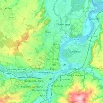
Name: Steyr topographic map, elevation, terrain.
Location: Steyr, Region Steyr-Kirchdorf, Upper Austria, 4400, Austria (48.02358 14.37622 48.08891 14.46993)
Average elevation: 1,119 ft
Minimum elevation: 899 ft
Maximum elevation: 1,640 ft
Make a donation
Gear up for your next adventure:
As an Amazon Associate, this site earns from qualifying purchases at no extra cost to you.
Other topographic maps
Click on a map to view its topography, its elevation and its terrain.
Point
Austria > Upper Austria > Bezirk Vöcklabruck > Frankenburg am Hausruck
Average elevation: 1,811 ft
Gerersdorf
Austria > Upper Austria > Bezirk Linz-Land > Hörsching > Gerersdorf
Average elevation: 974 ft
Prandegg
Austria > Upper Austria > Bezirk Freistadt > Schönau im Mühlkreis > Prandegg
Average elevation: 2,057 ft
Schauerschlag
Austria > Upper Austria > Bezirk Urfahr-Umgebung > Schauerschlag
Average elevation: 2,346 ft
Make a donation
Gear up for your next adventure:
As an Amazon Associate, this site earns from qualifying purchases at no extra cost to you.