
Branston topographic map
Interactive map
Click on the map to display elevation.
About this map
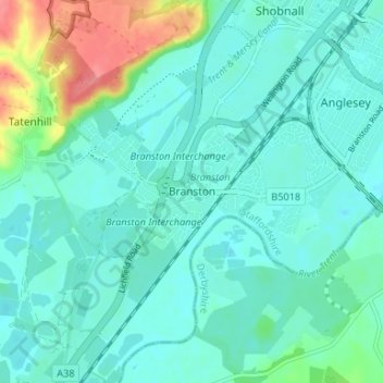
Name: Branston topographic map, elevation, terrain.
Average elevation: 180 ft
Minimum elevation: 135 ft
Maximum elevation: 354 ft
Other topographic maps
Click on a map to view its topography, its elevation and its terrain.
Tatenhill
United Kingdom > England > Staffordshire > East Staffordshire > Tatenhill
Tatenhill, East Staffordshire, Staffordshire, England, DE13 9FW, United Kingdom
Average elevation: 262 ft
Marchington
United Kingdom > England > Staffordshire > East Staffordshire > Marchington
Marchington, East Staffordshire, Staffordshire, England, United Kingdom
Average elevation: 335 ft
Yoxall
United Kingdom > England > Staffordshire > East Staffordshire > Yoxall
Yoxall, East Staffordshire, Staffordshire, West Midlands, England, United Kingdom
Average elevation: 292 ft