
Make a donation
Gear up for your next adventure:
As an Amazon Associate, this site earns from qualifying purchases at no extra cost to you.
Ortler - Ortles topographic map
Click on the map to display elevation.
Make a donation
Gear up for your next adventure:
As an Amazon Associate, this site earns from qualifying purchases at no extra cost to you.
Ortler - Ortles
The Ortler was first climbed by Josef Pichler [de] ("Pseirer-Josele"), a chamois hunter from St. Leonhard in Passeier, and his companions Johann Leitner and Johann Klausner from Zell am Ziller on 27 September 1804. The ascent had been a request of Archduke Johann of Austria, who felt strongly that after the first ascent of the Großglockner (3,798 m) in 1800, the highest mountain in his brother's empire ought to be climbed. The archduke ordered Johannes Nepomuk Gebhard, a "mountain official" and topographer from Salzburg, to climb the mountain with locals. The first five attempts failed and Gebhard was ready to give up, when Pichler responded to the prize money offered for reaching the peak. Pichler and his friends took a difficult, and because of avalanche danger until recently disused, route over the northwest face from Trafoi. (The route was re-opened in 2004.)
Make a donation
Gear up for your next adventure:
As an Amazon Associate, this site earns from qualifying purchases at no extra cost to you.
About this map
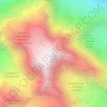
Name: Ortler - Ortles topographic map, elevation, terrain.
Average elevation: 10,417 ft
Minimum elevation: 7,464 ft
Maximum elevation: 12,694 ft
Make a donation
Gear up for your next adventure:
As an Amazon Associate, this site earns from qualifying purchases at no extra cost to you.