
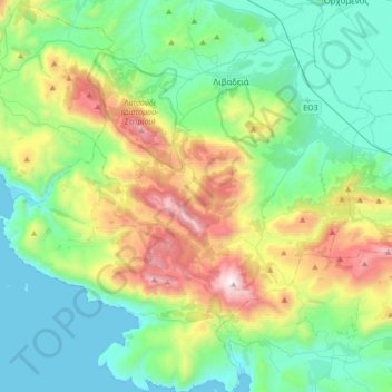
Levadia Municipal Unit topographic map
Interactive map
Click on the map to display elevation.
About this map
Name: Levadia Municipal Unit topographic map, elevation, terrain.
Average elevation: 1,535 ft
Minimum elevation: 0 ft
Maximum elevation: 5,689 ft
Other topographic maps
Click on a map to view its topography, its elevation and its terrain.
Livadia
Greece > Thessaly and Central Greece > Regional Unit of Boeotia > Levadia Municipal Unit
Livadia, Levadia Municipal Unit, Municipality of Livadia, Regional Unit of Boeotia, Central Greece, Thessaly and Central Greece, 321 00, Greece
Average elevation: 1,027 ft
Pyli
Greece > Thessaly and Central Greece > Regional Unit of Boeotia > Δημοτική Ενότητα Δερβενοχωρίων
Pyli, Δημοτική Ενότητα Δερβενοχωρίων, Municipality of Tanagra, Regional Unit of Boeotia, Central Greece, Thessaly and Central Greece, 190 12, Greece
Average elevation: 1,883 ft
Δημοτική Ενότητα Δερβενοχωρίων
Greece > Thessaly and Central Greece > Regional Unit of Boeotia
Δημοτική Ενότητα Δερβενοχωρίων, Municipality of Tanagra, Regional Unit of Boeotia, Central Greece, Thessaly and Central Greece, Greece
Average elevation: 1,368 ft
Cheronia
Greece > Thessaly and Central Greece > Regional Unit of Boeotia > Cheronia
Cheronia, Χαιρώνεια - Ακόντιο, Κοινότητα Χαιρώνειας, Cheronia, Municipality of Livadia, Regional Unit of Boeotia, Central Greece, Thessaly and Central Greece, 321 00, Greece
Average elevation: 482 ft
Arachova
Greece > Thessaly and Central Greece > Regional Unit of Boeotia > Δημοτική Ενότητα Αραχώβης > Arachova
Arachova, Δημοτική Ενότητα Αραχώβης, Distomo-Arachova-Antikyra Municipality, Regional Unit of Boeotia, Central Greece, Thessaly and Central Greece, 32004, Greece
Average elevation: 2,956 ft
Tanagra
Greece > Thessaly and Central Greece > Regional Unit of Boeotia > Δημοτική Ενότητα Τανάγρας > Tanagra
Tanagra, Δημοτική Ενότητα Τανάγρας, Municipality of Tanagra, Regional Unit of Boeotia, Central Greece, Thessaly and Central Greece, 32009, Greece
Average elevation: 758 ft