Geolocate

Seaton topographic map

Click on the map to display elevation.

About this map

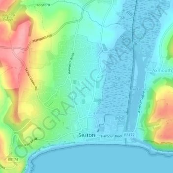
Name: Seaton topographic map, elevation, terrain.

Location: Seaton, East Devon, Devon, England, United Kingdom (50.69868 -3.08965 50.72539 -3.05866)

Average elevation: 108 ft

Minimum elevation: -23 ft

Maximum elevation: 420 ft

Gear up for your next adventure:

🪵Folding Camp Saw - Compact saw for wood and campsite work
🏫Relief Map Kits - Hands-on tools for teaching landforms and elevation
🧭Orienteering Set - Complete compass and map reading kit
🎒Outdoor Daypacks - Lightweight backpacks designed for carrying maps and essential gear
🗺️Topographic Maps - Detailed topo maps for hiking, exploring and outdoor navigation

As an Amazon Associate, this site earns from qualifying purchases at no extra cost to you.