
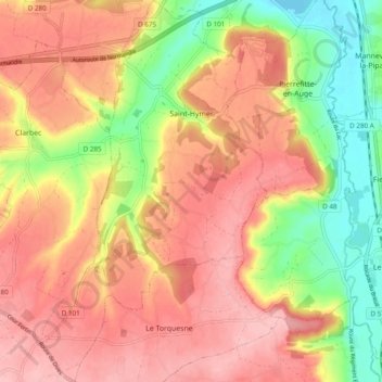
Saint-Hymer topographic map
Interactive map
Click on the map to display elevation.
About this map
Name: Saint-Hymer topographic map, elevation, terrain.
Average elevation: 305 ft
Minimum elevation: 36 ft
Maximum elevation: 495 ft
Other topographic maps
Click on a map to view its topography, its elevation and its terrain.
Cully
France > Normandie > Calvados > Moulins en Bessin
Cully, Moulins en Bessin, Bayeux, Calvados, Normandie, France métropolitaine, 14480, France
Average elevation: 161 ft
Bretteville-sur-Laize
Bretteville-sur-Laize, Caen, Calvados, Normandie, France métropolitaine, 14680, France
Average elevation: 312 ft
La Villette
La Villette, Vire, Calvados, Normandie, France métropolitaine, 14570, France
Average elevation: 673 ft
Monceaux-en-Bessin
Monceaux-en-Bessin, Bayeux, Calvados, Normandie, France métropolitaine, 14400, France
Average elevation: 207 ft
Les Monceaux
Les Monceaux, Lisieux, Calvados, Normandie, France métropolitaine, 14100, France
Average elevation: 486 ft
Condé-en-Normandie
France > Normandie > Calvados > Condé-en-Normandie
Condé-en-Normandie, Vire, Calvados, Normandie, France métropolitaine, 14770, France
Average elevation: 528 ft
Mondeville
Mondeville, Caen, Calvados, Normandie, France métropolitaine, 14120, France
Average elevation: 72 ft
Russy
France > Normandie > Calvados > Aure sur Mer
Russy, Aure sur Mer, Bayeux, Calvados, Normandie, France métropolitaine, 14710, France
Average elevation: 115 ft